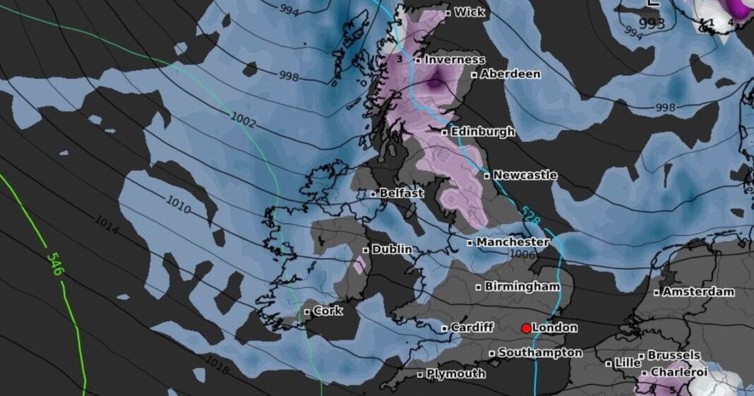
Britain is on track to encounter a substantial 320-mile expanse of snow over the upcoming days due to a drop in temperatures starting this weekend. According to the latest weather data from WXCharts utilizing Metdesk information, a vast area stretching from Leeds, England to Wick in Scotland is anticipated to be covered in snowfall by November 5. Conversely, other regions in the UK such as Northern Ireland, Wales, and southwest England are expected to receive rainfall, while London and parts of southern and southeast England are likely to remain dry.
Forecasters suggest that snowfall may also occur in certain parts of the country, primarily in Scotland, during the weekend. Moreover, additional snow is predicted for Monday, October 27, with coastal regions in eastern and western England projected to be affected as well, as per WXCharts.
After a period of mild anticyclonic conditions, the upcoming days are expected to bring unsettled weather, as stated by the Met Office. Following showers in various areas including southern England, southern Wales, and northwestern Scotland on Monday, more rainfall is foreseen for Tuesday.
Meteorologists anticipate intermittent sunshine amidst the showers and a decrease in strong winds. Wednesday is anticipated to offer the best weather conditions of the week, with dry and sunny spells expected for central and eastern regions.
Nevertheless, some areas in Northern Ireland, western Scotland, and the Northern Isles may experience showers along with light rain in the southernmost areas. Subsequently, from Wednesday afternoon, a transition in weather patterns is expected from the west, with heavy rain and intensified winds moving in as a low-pressure system crosses the southern coast.
Tom Crabtree, the deputy chief forecaster at the Met Office, highlighted the likelihood of increasingly unsettled weather from Wednesday evening onwards. Overnight on Wednesday, heavy rain and gusty winds are anticipated to sweep across southern UK regions. Accumulations of 25-40mm of rain within a twelve-hour period are feasible in southern counties.
The Met Office warns that the unsettled conditions will expand across the UK through Thursday, bringing heavy showers and additional rainfall to various regions. There is a potential for severe weather warnings to be issued due to the uncertain positioning and details of the low-pressure system. It is advised for individuals to stay updated with weather forecasts as the week progresses.
By Friday, strong winds are expected to concentrate along the east coast of England and Scotland owing to low pressure. The Met Office forecasts a spread of “cooler, arctic maritime” conditions southwards across the UK, resulting in below-average temperatures by Saturday across most regions.
Meteorologists mentioned the possibility of wintry showers over Scottish mountains as temperatures decline. The long-term forecast from the Met Office for the upcoming weeks suggests a shift to increasingly changeable and unsettled weather patterns, with systems moving in from the west, bringing bouts of rain and strong winds intermittently.
Continuing into the evening and overnight, showers are expected to persist, mainly in western areas, with potential heavy showers and thunder. While winds may ease slightly, coastal regions in the south are likely to remain windy.
Tuesday is anticipated to be a mixed day with sunny intervals and blustery showers, particularly in the north and west, with pleasant conditions during sunnier spells.
Wednesday is expected to be mostly dry for many regions before transitioning to wet and windy weather on Thursday. Friday is likely to remain windy with heavy showers following the clearing of rain, and a further drop in temperatures is expected by the end of the week.
